
SPARC AI Proves Drones Can Navigate GPS-Denied Skies Completely Blind
How SPARC AI’s camera-free, software-only Overwatch network is solving the defense industry's biggest GPS-denied battlefield bottleneck.
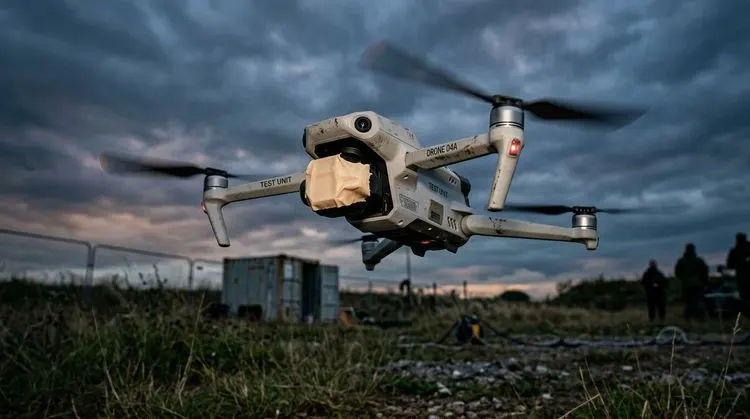
Flying completely blind is usually a drone pilot’s worst nightmare, but for SPARC AI Inc. (CSE: SPAI | OTCQB: SPAIF), it was just another day at the flight test pattern, and a loud statement to the defense technology sector.
In a series of live flight trials, the defense technology outfit physically covered and blindfolded a drone's camera lens for the entire duration of a structured test flight. Despite zero optical visibility, the platform’s flagship Overwatch Positioning Network accurately calculated target coordinates using raw flight telemetry alone. The onboard camera was rendered completely non-functional as a positioning sensor, confirming a deliberate design principle of the Overwatch architecture: the calculation relies on zero computer vision, no image recognition software, and no pre-loaded reference terrain maps.
Most traditional approaches attempting to solve uncrewed navigation in GPS-denied or signal-jammed environments rely heavily on Visual Inertial Odometry or optical terrain matching. While impressive in clean conditions, vision-dependent systems routinely degrade or outright fail at night, in heavy fog, thick smoke, dust storms, over open water, across featureless snow, or in barren deserts. Furthermore, they demand that operators collect and upload high-resolution maps of the target zone beforehand, requiring energy-hungry onboard processing hardware that adds weight and drains flight time.
Overwatch bypasses these environmental and hardware limitations by operating strictly on telemetry data that standard commercial flight controllers already generate. Delivered as a lightweight API, the system ingests basic flight metrics and outputs standard latitude, longitude, and timestamps, formatting the output so it appears to the autopilot as a conventional GPS fix without requiring airframe redesigns.
Because Overwatch processes no optical imagery, no visual data ever leaves the aircraft during field operations. Combined with a stateless architecture that retains no operational data, the platform eliminates significant security hurdles for government and defense agencies undergoing data-privacy reviews.
Equally important for drone manufacturers is that Overwatch avoids being a costly "rip-and-replace" installation. Original equipment manufacturers can integrate the software layer into existing production workflows as a primary positioning source, a blended sensor input, or an instant backup when satellite navigation is jammed or spoofed.
As we at JuniorStocks have highlighted in previous coverage, software-first architectures are quickly becoming the preferred route for maintaining uncrewed capability in electronic warfare theaters.
Addressing the core challenge of contested airspace, SPARC AI U.S. CEO Matt McCrann noted that unassisted low-cost inertial sensors drift too quickly when satellite navigation is denied, making software stabilization essential to deliver usable targeting without dragging down aircraft payloads.
Defense partners are actively putting this approach into production. Defense drone manufacturer Rate Manufacturing recently partnered with the company to integrate Overwatch across its Model-F multi-mission uncrewed systems. Rate Manufacturing CEO Jamie Waller underscored that the software-based approach delivers reliable GPS-denied targeting to operators without adding physical hardware weight, inflating production costs, or requiring specialized pilot retraining.
With major allied military initiatives prioritizing resilient, mass-producible drone fleets capable of operating through severe electromagnetic interference, camera-independent navigation is shifting from a specialized perk to a baseline requirement. By proving its software can pinpoint targets while wearing a literal blindfold, SPARC AI Inc. (CSE: SPAI | OTCQB: SPAIF) continues to demonstrate how software agility can solve defense hardware bottlenecks.
Sources
- GlobeNewswire / SPARC AI Inc. Press Release (Sept. 01, 2026) – "SPARC AI Flies Blind and Still Hits the Mark: Overwatch Locates Targets with Drone Camera Fully Covered"
- Streetwise Reports Analyst Review (Sept. 03, 2026) – "Sparc AI Overwatch Confirms Blindfold Drone Positioning in Tests"
- GlobeNewswire / Corporate Announcement (May 20, 2026) – "SPARC AI and Rate Manufacturing Partner to Scale GPS-Denied Drone Capability"
Disclaimer
Neither the author of this article nor JuniorStocks holds equity, stock options, or any other financial positions in SPARC AI Inc. (CSE: SPAI; OTCQB: SPAIF; Frankfurt: 5OV0) or any other companies mentioned in this publication. This content is published by JuniorStocks strictly for informational purposes, was prepared independently without company compensation, and utilized AI assistance for text editing, formatting, and generating accompanying media. While defense technology and GPS-denied autonomous navigation represent a compelling frontier in uncrewed systems, this article does not constitute investment or financial advice. Investors are strongly advised to conduct their own thorough, independent due diligence and consult with a qualified financial professional before making any investment decisions.